Back in early June, Adobe and Igalia announced a collaboration to work on the CSS Regions and CSS Shapes W3C standards. Our first challenge has been to improve the Selection use cases when using complex layout models, like CSS Regions.
The CSS Regions model allows content to flow across multiple areas called Regions. This new approach offers web content designers a way to build richer and more complex layouts, mapping content with specific visual areas of a document. Defining different Flow Threads with multiple Regions, associating them to specific content, and applying different styles to a set of Regions is very powerful in terms of design and user experience. If you are interested, here you can find some examples of what is possible with CSS Regions.
But having this flexibility in web design requires overcoming quite a few technical challenges. The current implementation of CSS Regions in WebKit changes the way the Render Tree is created from the DOM Tree. This poses the challenge of making selection work with regions since selection is DOM based. Given its importance and frequent use, improving the interaction of selection and CSS Regions has been the main goal of our collaboration.
The W3C selection specification, which has not been updated since the last year, does not address the complexities introduced by new layout modules, like CSS Regions, CSS FlexBox and CSS Grid Layout module . We found out very quickly that selection had many issues, with respect to both visual appearance and selected content. We have created a tests suite to evaluate the different use cases of selection with CSS Regions.
|
|
|
Let’s start with a very simple description of the concept of Selection Direction, which consist of the following points:
- The WebCore::VisibleSelection class has two attributes called base and extent declared as dom::Position instances
- Such positions refer respectively to the anchor and focus nodes in the DOM Tree.
- Additionally, WebCore::VisibleSelection has two dom:Position attributes, start and end, which are used later during the rendering phase
Once the base and extent fields are set when instantiating a new VisibleSelection class, some adjustments and checks are performed to validate the selection. One of those checks is whether base position is before extent in the DOM Tree. Based on the result of this check, the start and end attributes will be set to either base or extent respectively.
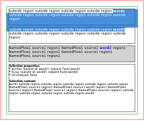
In the first test, the selected content includes the entire region block, even when it was not selected by the user. The cause, as we will see in later, derives from the position of the source block in the DOM Tree, which in this case is defined between the two regular blocks.
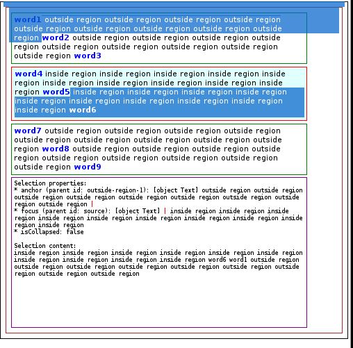
The second example shows some selection direction related issues; in this case, what the user selected is precisely the content between the two highlighted areas. The problem here is that the base node of the original selection is below the extent node in the DOM Tree, so they are swapped in the selection logic. In addition, the CSS Regions implementation builds the Render Tree in a way that the source content defined by a RenderNamedFlowThread block is positioned below where it was defined in the DOM Tree. The consequence of this is that the start node is below the end node, so the highlighted area starts in the region block and continues from the root element (usually the body) until reaching the end node.
Our first approach was trying to provide a better user experience during selection with CSS Regions. We thought that adding multi-range capabilities to the DOM Selection API was the best way to go and we provided a patch. However, this approach was rejected by some Apple reviewers because multi-range selection introduces many problems, such as those detailed in the selection specification.
We have opened the debate again on the mailing list, though, because we think there might be some advantages to this approach, even without modifying the selection API. For instance, being able to handle independent Ranges and compose the expected selection will provide the flexibility needed to implement complex use cases. But, after some discussion with some of the Adobe Web Platform contributors, we have decided to focus on improving the selection following the current specification. While we feel this approach may lead to a non-optimal user experience for certain use cases, we expect implementing it will help us discover the problems inherent in the current selection specification. We have also been discussing these issues with some reviewers from Apple, Ryosuke Niwa and David Hyatt, and looking for alternatives to the multi-range approach.
We have posted additional patches, one to improve the selection behavior and another to revert the current limitation of selections related to including content from different Flow Threads. We think that this approach provides better integration of CSS Regions with HTML documents. Plus, it will allow us to properly evaluate the performance issues of selection with CSS Regions.
The other challenges we faced during this collaboration include:
- changing how the selection rendering traverses the Render Tree in order to deal with the special RenderFlowThread blocks
- adjusting the block gaps filling algorithm
- clearing the selection
- selection direction issues derived from the Render Tree and DOM Tree divergence
We detected a number of other issues, such as how LayoutPoints are positioned in the DOM Tree when pointing to Region blocks, leading to an incorrect Selection extent node. We are confident that we will ultimately have a fully-compliant selection specification implementation for CSS Regions, but the improvements using this approach are limited. Even after solving all the issues we have detected so far, selection might still seem weird and buggy from an end user perspective. Thus we think that the final solution, one which will provide the user with a more consistent experience, will be to complement the selection specification to consider not only the DOM Tree, but also how the Render Tree is built by the Layout Model.